-
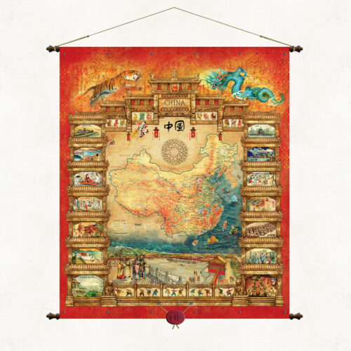
A unique map filled with oriental style illustrates both the cartographic image of China and the specific nature and culture of the center country and its cantons. At the bottom of the map is one of the most recognizable symbols of China, the Square of Heavenly Peace (Tiananmen Square). The side frames show the most famous monuments and symbols of Chinese culture and tradition. The publication is bound on wooden poles with decorative tips and topped with a suspended Chinese wax seal. The publication belongs to a series of maps created at the request of the Polish Olympic Committee. It was made in 2008 for the XXIX Summer Olympic Games, which took place in Beijing, the capital of China.
-
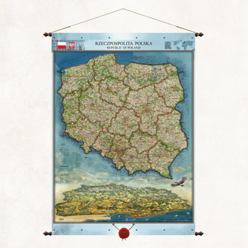
This is a unique map on our publishing market. In addition to its classic cartographic content, it also presents a unique landscape image of Poland. We have combined two complementary views on one map. Our artists have painted Poland “from an eagle’s eye view” to illustrate the beauty of our homeland and its assets. Wanting to show the Polish mountains in a clear perspective, we have reversed the observer’s position to the north. We have marked the panorama with the most important cities, monuments, rivers, and forests. This is how this unique and practical landscape publication was created.
-
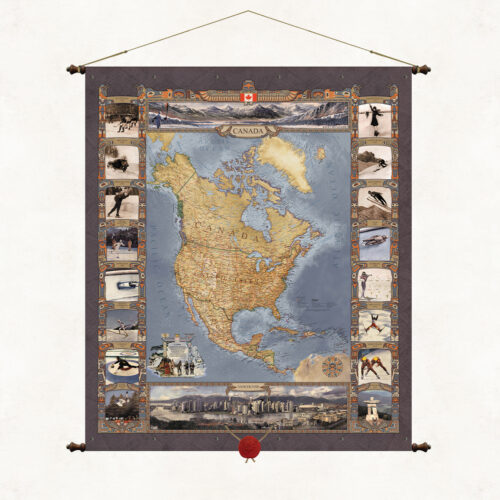
A map of Canada, or rather a map of North America. A publication commissioned by the Polish Olympic Committee for the XXI Winter Olympic Games, which took place in the Canadian city of Vancouver on 12–28 February 2010. This is another in a series of Olympic maps. The map frames and cartouches refer stylistically to the totemic culture of the North American Indians. The upper part of the publication shows a winter view of the Rocky Mountains region, where the games were held, the lower part shows the panorama of the city of Vancouver.
-
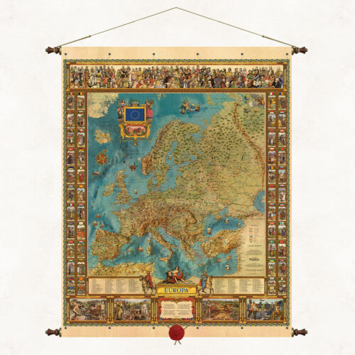
The Map of Europe is one of the leading publications of our publishing house, created by outstanding Silesian artists Kazimierz and Ksawery Kaliski. The publication’s original graphic and thematic composition captivates with its colors and richness of content. The unique map refers stylistically to old editorial forms, but presents Europe much deeper, fuller and more beautifully. In symbols and images, it shows the cross-sectional richness of the centuries-old cultural heritage of the old continent, its state and national specificity. It is framed on wooden rods with decorative ends and topped with a suspended wax seal.
-
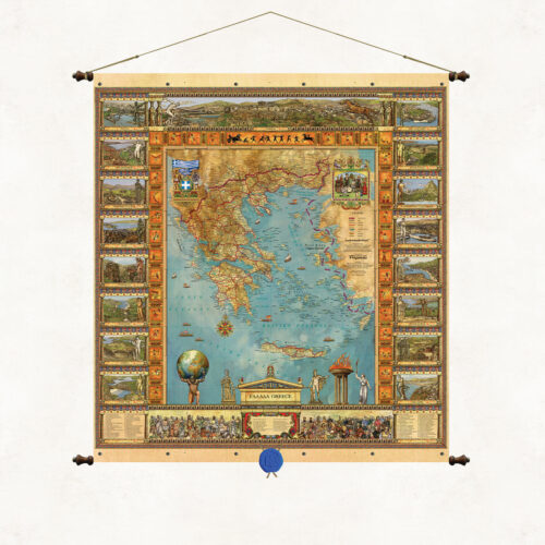
The beautiful graphic and color composition of the map illustrates both the cartographic image of the lands of Greece and its historical and cultural heritage. The enchanting landscapes, ancient architecture and a list of outstanding figures from the history of Greece shown in cross-section on the map are a compendium of knowledge about the cradle of our civilization. The publication belongs to a series of maps created at the request of the Polish Olympic Committee. It was made for the XXVIII Summer Olympic Games held in Athens (Greece) in 2004.
-
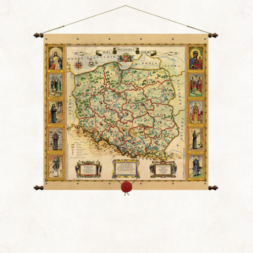
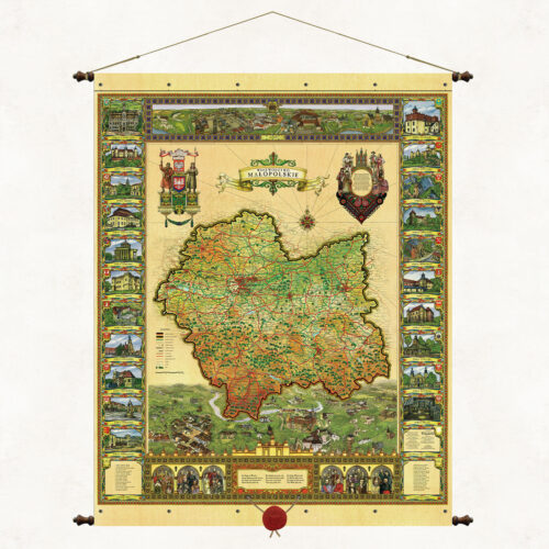
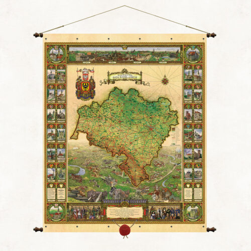
The stylized graphic and color composition of the map illustrates both the cartographic image of contemporary Polish lands and the natural and cultural specificity of individual regions. The side cartouches refer to the contemporary administrative division of the country. Each voivodeship is illustrated in a separate frame. There we can see its characteristic monuments, terrain, vegetation, and regional folk costume. At the bottom of the map we have shown a list of outstanding figures from the history of Poland. Illustrations depicting great leaders, scientists and artists are an instructive story about the thousand-year history of our country.
-
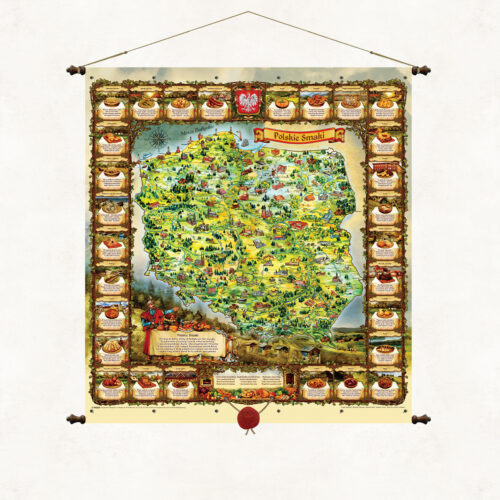
Here is a country abundant in goods from the Baltic Sea to the peaks of the Tatra Mountains Here food recipes are part of an old culture with a hint of Slavic spirit and for the senses as well as the belly. It is an old Polish tradition to feast among delicacies so let's sit in a circle together the table is already set. And let's choose Polish dishes because it's a delight to eat. The unique map Polish Flavors brings the uniqueness of Polish culinary tradition closer. The rhymed descriptions of the most famous Polish dishes surround a colorful, landscape representation of the Polish lands. A lavishly set table, a nobleman in a kontusz and an old-Polish inviting gesture encourage the tasting of Polish dishes. The original descriptions of the dishes are poems by Father Marek Wójcicki written especially for this publication. The publication is thematically inscribed in our publishing mission, which is to promote Poland, its beauty, history and traditions. Images painted by artist Marek Michna and illustrator Radoslaw Jaszczuk.
-
This is the first publication of the Pergamena Publishing House, created as a souvenir of the millennium year. Maintained in the convention of old maps, it presents the diocesan administrative division of the Catholic Church in Poland. The side cartouches feature images of the Merciful Christ, Our Lady of Częstochowa and outstanding saints from the history of the Polish church. The lower cartouches feature the blessing of St. John Paul II and the text of the Chaplet of Divine Mercy.
-
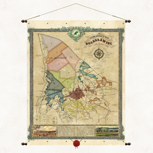
An overview map of the Bolesławiec Forest District, one of 33 forest districts that are part of the Regional Directorate of State Forests in Wrocław. The map presents a brief description of the forest district, forest divisions and forest habitat types. The Bolesławiec Forest District is located entirely within the Lower Silesian Voivodeship in Bolesławiec County. It consists of 6 communes: Bolesławiec, Warta Bolesławiecka, Osiecznica, Nowogrodziec, Gromadka and the City of Bolesławiec.
-
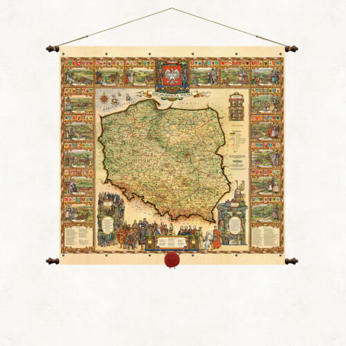
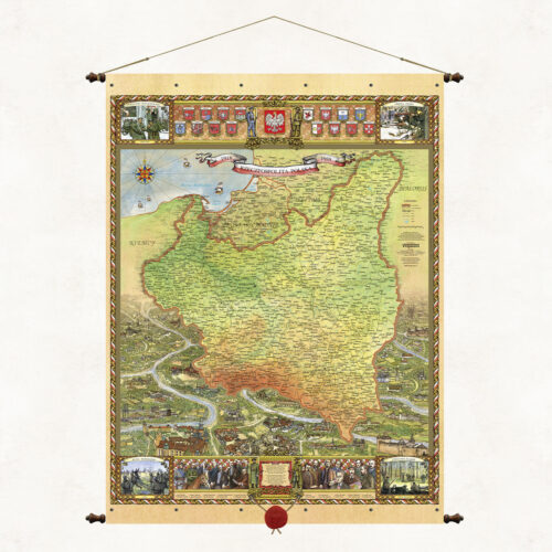
The map shows the borders of the Republic of Poland in the interwar period, along with the administrative division of the country. In addition to the cartographic layer, the map will include engravings presenting the panorama of the lands of the Second Polish Republic with characteristic monuments, coats of arms of the then voivodeships, a list of outstanding figures, creators and leaders of the Second Polish Republic, images of the four independence uprisings that determined the shape of the borders of Poland at that time (Battle of Warsaw, Greater Poland Uprising, Sejny Uprising and Defense of Lviv).
More information? Call: +48 501 69 59 69