-
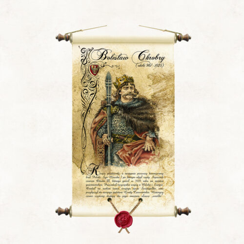
Scroll with an image of King Bolesław Chrobry, painted in watercolour by the artist of our publishing house, Marek Miha. The portrait is a colourful interpretation of drawings from the cycle Poczet królów i książąt polskich executed in pencil by Jan Matejko. BOLESŁAW CHROBRY (967 - 1025) The son of Mieszko I, the first crowned king of Poland. He was an ally of Emperor Otto III, whom he hosted in Gniezno in 1000. He waged victorious wars over Milsko and Lusatia. He organised missionary expeditions to Kyiv. He installed his son-in-law, Svyatopolk, on the throne of Kyiv, and recaptured the Chernivian lands previously occupied by Prince Vladimir of Kyiv, incorporating them into his own state. Historians are increasingly adding the word ‘Great’ to his name.
-
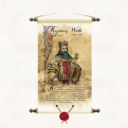
A scroll with an image of King Casimir the Great, painted in watercolour by the artist of our publishing house, Marek Miha. The portrait is a colourful interpretation of drawings from the series Poczet królów i książąt polskich (A Selection of Polish Kings and Princes) made in pencil by Jan Matejko. KAZIMIERZ THE GREAT (1310 - 1370) The last of the Piast dynasty, king of Poland from 1333. Due to the construction of dozens of new cities, as well as the expansion or construction of several hundred new castles and fortresses, he was called ‘the one who found Poland wooden and left it brick’. The talented ruler was also famous for the small number of wars fought and an effective foreign policy. His reign consolidated the unification process of the Polish lands and brought Poland out of political isolation in Europe, after nearly two centuries of district disintegration.
-
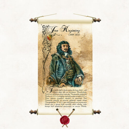
Scroll with an image of King Jan Kazimierz, painted in watercolour by the artist of our publishing house, Marek Miha. The portrait is a colourful interpretation of drawings from the series Poczet królów i książąt polskich (A Selection of Polish Kings and Princes) made in pencil by Jan Matejko. JAN KAZIMIERZ (1609 - 1672) He assumed the Polish throne at a very difficult moment for the country - the whole of Ukraine was covered by the Khmelnytsky uprising. One war had not yet ended when the Republic was attacked by Moscow (1654), followed by the Swedish deluge (1655). Despite repulsing all invasions, the first symptoms of the disintegration of the Commonwealth's political system appeared during the reign of Jan Kazimierz (the first Sejm in 1652, broken off by the liberum veto, and the nobility's rebellion). The King abdicated, leaving Poland forever.
-
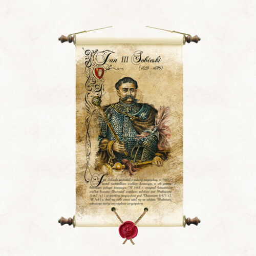
Scroll with an image of King Jan III Sobieski, painted in watercolour by the artist of our publishing house Marek Miha. The portrait is a colourful interpretation of drawings from the cycle Poczet królów i książąt polskich executed in pencil by Jan Matejko. JAN SOBIESKI (1629 - 1696) He came from a magnate family. In 1674, the nobility elected him king. Jan III Sobieski was an outstanding commander who achieved some of the greatest military successes of Polish arms, including the Battle of Chocim (1673) and the famous relief of Vienna (1683). He was also a great patron of culture and the arts. On the other hand, he did little in matters of foreign, domestic policy and economy. He did not stop the negative processes decaying the Polish state with increasing speed.
-
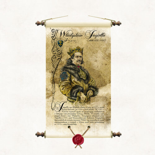
Scroll with an image of King Ladislaus Jagiello, painted in watercolour by the artist of our publishing house, Marek Miha. The portrait is a colourful interpretation of the drawings from the cycle Poczet królów i książąt polskich executed in pencil by Jan Matejko. WŁADYSŁAW JAGIEŁŁO (1362 - 1434) Jagiełło, son of Olgierd, ruler of Lithuania, from 1377 Grand Duke of Lithuania. In 1385 he married Jadwiga of Anjou and concluded a personal union between Lithuania and Poland. As a result, he was baptised and named Ladislaus. In 1386, he became the Polish king. The victory won by Jogaila at Grunwald in 1410 over the Teutonic Order led to an increase in the importance of Poland and its monarch in the international arena, and the union with Lithuania was strengthened in 1413 with the Union of Horodela.
-
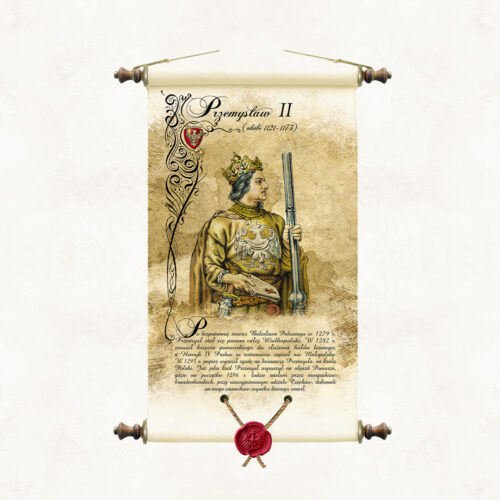
Scroll with an image of Prince Przemysl II, painted in watercolour by the artist of our publishing house, Marek Miha. The portrait refers stylistically to the series of drawings Poczet królów i książąt polskich by Jan Matejko, in which the artist did not include an image of Prince Przemysl II. PRZEMYSŁ II After the heirless death of Boleslaw the Pious in 1279, Przemysl became lord of the whole of Greater Poland. In 1282, he forced the Duke of Pomerania to pay a fief tribute. Henry IV Probus bequeathed Malopolska to him in his will. In 1295, the Pope consented to the coronation of Przemysl, as king of Poland. In 1296, Przemysl set out on a tour of Pomerania, where he was assassinated, with the unexplained involvement of Czechs, by the Brandenburg margraves.
-
BASIC OFFER The paintings we offer are available in two widths, depending on the image's orientation: – Landscape paintings are 95 cm wide – Portrait paintings are 65 cm wide. The price of the paintings does not depend on the width, but on whether they are printed on canvas or paper, and on the type of frame or frameless frame. Their height varies and depends on the proportions specified by the artist. The price for both widths is the same and is: – Canvas print on a roll: PLN 490.00 / 1 m² – Canvas print on stretcher bars: PLN 590.00 / 1 piece – Canvas print with Pergamena frame: PLN 550.00 / 1 piece – Double-sided laminated paper print with Pergamena frame: PLN 470.00 / 1 piece FRAMES We do not sell framed paintings. The frames shown in the painting visualizations are for illustrative purposes only and are not part of our sales offer. AUTOGRAPH Paintings from our gallery are signed by the artist on each canvas and confirmed by a certificate of authenticity. LARGER FORMAT PAINTINGS We also offer paintings in larger formats. They are sold only in rolls for individual framing. The cost of larger format paintings is the painting's surface area in m², calculated including a 6-centimeter margin, multiplied by PLN 490.00. For example, the actual canvas dimensions of a 110 cm x 80 cm painting, including the margin for framing, are 122 cm x 92 cm. Due to technical constraints, the maximum height of landscape paintings offered is 135 cm, and the maximum width of portrait paintings is 135 cm. Additionally, we add domestic shipping costs of PLN 15 for rolls and bound parchments, and PLN 35 for stretcher paintings. International shipping costs are calculated individually depending on the country and carrier. PERGAMENA BINDING Pergamena Publishing's stylized binding – a form of framing characterized by proprietary technical solutions and an original composition of design details. The binding evokes the traditional method of hanging wall publications on wooden rods. The supporting rods are inserted at the top and bottom of the publication into sleeves created by folding the material and joining it lengthwise with decorative rivets. The rods are topped with wooden knobs with metal fittings, to which a decorative hanging cord is attached at the top. The lower part of the painting is stamped with a synthetic sealing wax image of the Piast eagle, suspended on strings.
-
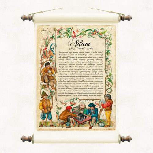
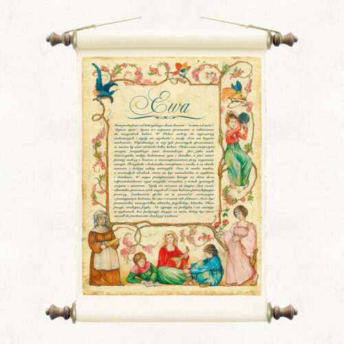
We offer a graphic and literary lexicon of names in the form of stylised scrolls. The page shows examples of two namesakes, female and male, Adam and Eve. In our publishing resources we have a collection of namesakes relating to most of the popular names from our cultural background. When ordering a namesake, please select the gender and name of the lady or gentleman for whom it will be intended. There is a possibility to place a short dedication or a wish for the recipient on the name tag. This is an additionally charged service.
-
BASIC OFFER The paintings we offer are available in two widths, depending on the image's orientation: – Landscape paintings are 95 cm wide – Portrait paintings are 65 cm wide. The price of the paintings does not depend on the width, but on whether they are printed on canvas or paper, and on the type of frame or frameless frame. Their height varies and depends on the proportions specified by the artist. The price for both widths is the same and is: – Canvas print on a roll: PLN 490.00 / 1 m² – Canvas print on stretcher bars: PLN 590.00 / 1 piece – Canvas print with Pergamena frame: PLN 550.00 / 1 piece – Double-sided laminated paper print with Pergamena frame: PLN 470.00 / 1 piece FRAMES We do not sell framed paintings. The frames shown in the painting visualizations are for illustrative purposes only and are not part of our sales offer. AUTOGRAPH Paintings from our gallery are signed by the artist on each canvas and confirmed by a certificate of authenticity. LARGER FORMAT PAINTINGS We also offer paintings in larger formats. They are sold only in rolls for individual framing. The cost of larger format paintings is the painting's surface area in m², calculated including a 6-centimeter margin, multiplied by PLN 490.00. For example, the actual canvas dimensions of a 110 cm x 80 cm painting, including the margin for framing, are 122 cm x 92 cm. Due to technical constraints, the maximum height of landscape paintings offered is 135 cm, and the maximum width of portrait paintings is 135 cm. Additionally, we add domestic shipping costs of PLN 15 for rolls and bound parchments, and PLN 35 for stretcher paintings. International shipping costs are calculated individually depending on the country and carrier. PERGAMENA BINDING Pergamena Publishing's stylized binding – a form of framing characterized by proprietary technical solutions and an original composition of design details. The binding evokes the traditional method of hanging wall publications on wooden rods. The supporting rods are inserted at the top and bottom of the publication into sleeves created by folding the material and joining it lengthwise with decorative rivets. The rods are topped with wooden knobs with metal fittings, to which a decorative hanging cord is attached at the top. The lower part of the painting is stamped with a synthetic sealing wax image of the Piast eagle, suspended on strings.
-
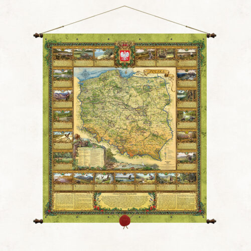
"Poland is a land of ancient primeval forests and thousands of lakes spread on hills and plains between the Baltic Sea and the high Tatra Mountains. History has endowed our country with a unique place on Earth, thanks to which beautiful Polish landscapes four times a year undergo extraordinary metamorphoses delighting with the dynamics of nature, its unusual colors and moods." The map “Nature of Poland” is a publcation unique and beautiful, full of images and symbols of the natural heritage of our country. It is a map - sanctuaries of Polish nature, which should, like the works of Mickiewicz, go under thatched roofs to give and strengthen in us a sense of connection with nature and responsibility for it. Maintained in the convention of old cartographic works, it tells about the treasures of nature that have survived to our time. It presents in decorative cartouches business cards of Polish national parks, gives the most important natural and geographical information about Poland, describes the forms of environmental protection used in our country, beautifully promotes Polish nature. Wishing to popularize the natural beauty of our country, we have published two twin maps, “Nature of Poland” and “Forests of Poland”, which in a complementary way present the overall resource of Polish nature. National parks are the mothers of Polish flora and fauna, but they are not a separate and independent natural creation, they are part of our natural environment, which includes many components such as forests, landscape parks, areas of protected landscape, agricultural land and, of course, water. National parks account for only 1% of our country's land area. The remaining 29% is made up of forest areas owned by the State Forestry Service.
-
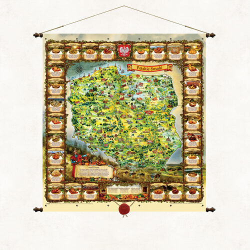
Here is a country abundant in goods from the Baltic Sea to the peaks of the Tatra Mountains Here food recipes are part of an old culture with a hint of Slavic spirit and for the senses as well as the belly. It is an old Polish tradition to feast among delicacies so let's sit in a circle together the table is already set. And let's choose Polish dishes because it's a delight to eat. The unique map Polish Flavors brings the uniqueness of Polish culinary tradition closer. The rhymed descriptions of the most famous Polish dishes surround a colorful, landscape representation of the Polish lands. A lavishly set table, a nobleman in a kontusz and an old-Polish inviting gesture encourage the tasting of Polish dishes. The original descriptions of the dishes are poems by Father Marek Wójcicki written especially for this publication. The publication is thematically inscribed in our publishing mission, which is to promote Poland, its beauty, history and traditions. Images painted by artist Marek Michna and illustrator Radoslaw Jaszczuk.
-
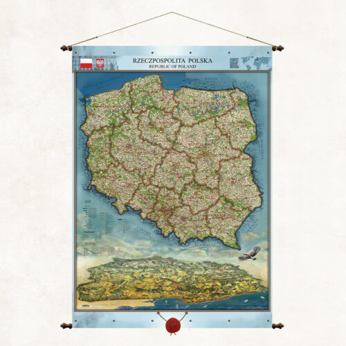
This is a unique map on our publishing market. In addition to its classic cartographic content, it also presents a unique landscape image of Poland. We have combined two complementary views on one map. Our artists have painted Poland “from an eagle’s eye view” to illustrate the beauty of our homeland and its assets. Wanting to show the Polish mountains in a clear perspective, we have reversed the observer’s position to the north. We have marked the panorama with the most important cities, monuments, rivers, and forests. This is how this unique and practical landscape publication was created.
-
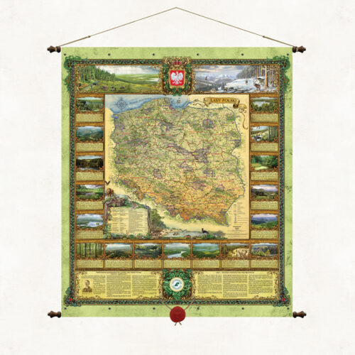
The "Forests of Poland" map presents a cartographic image of Polish forests, the structure and administrative boundaries of the State Forests, the headquarters of forest districts and regional directorates, as well as the location of the most important primeval forests, coniferous forests, forests, national parks and Promotional Forest Complexes in Poland. The decorative cartouches of the map show representative landscapes found in individual regional directorates, as well as selected animal species characteristic of the nature of our country. Forest areas cover almost 30% of the area of Poland. This is where the main natural resource of our country is located. Most of this area is managed by the State Forests, whose task, included in the mission of the company, is to protect and shape the natural environment. Each administrative unit of the State Forests, each forester is de facto ambassadors of Polish nature. They are the ones who perform this daily ant work, the effects of which are not always noticed, but will certainly be appreciated by future generations. It is to them that we owe the development and good condition of the natural well-being of our homeland.
-
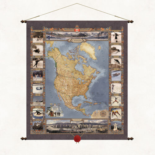
A map of Canada, or rather a map of North America. A publication commissioned by the Polish Olympic Committee for the XXI Winter Olympic Games, which took place in the Canadian city of Vancouver on 12–28 February 2010. This is another in a series of Olympic maps. The map frames and cartouches refer stylistically to the totemic culture of the North American Indians. The upper part of the publication shows a winter view of the Rocky Mountains region, where the games were held, the lower part shows the panorama of the city of Vancouver.
-
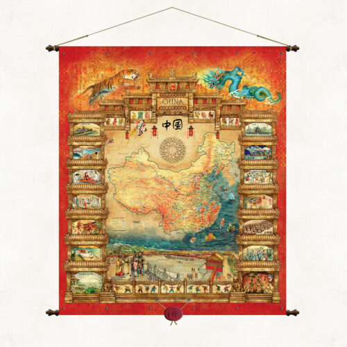
A unique map filled with oriental style illustrates both the cartographic image of China and the specific nature and culture of the center country and its cantons. At the bottom of the map is one of the most recognizable symbols of China, the Square of Heavenly Peace (Tiananmen Square). The side frames show the most famous monuments and symbols of Chinese culture and tradition. The publication is bound on wooden poles with decorative tips and topped with a suspended Chinese wax seal. The publication belongs to a series of maps created at the request of the Polish Olympic Committee. It was made in 2008 for the XXIX Summer Olympic Games, which took place in Beijing, the capital of China.
-
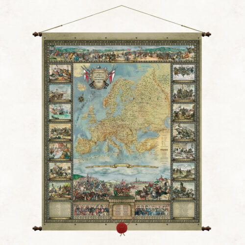
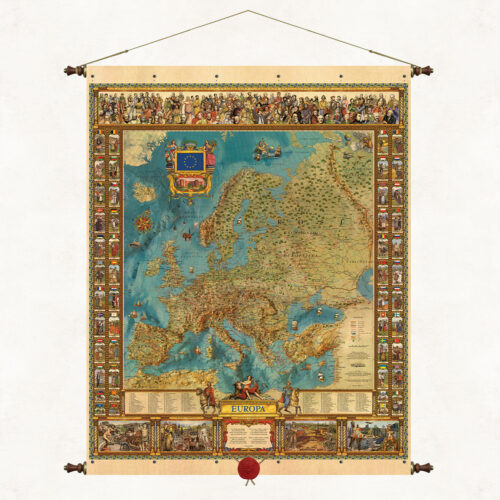
The Map of Europe is one of the leading publications of our publishing house, created by outstanding Silesian artists Kazimierz and Ksawery Kaliski. The publication’s original graphic and thematic composition captivates with its colors and richness of content. The unique map refers stylistically to old editorial forms, but presents Europe much deeper, fuller and more beautifully. In symbols and images, it shows the cross-sectional richness of the centuries-old cultural heritage of the old continent, its state and national specificity. It is framed on wooden rods with decorative ends and topped with a suspended wax seal.
More information? Call: +48 501 69 59 69