-
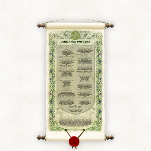
The prayer called Saint Patrick's Breastplate is one of the most interesting relics of early Christianity. This type of hymn of an apotropaic and exorcistic nature was widely used in Ireland and Scotland between the 5th and 12th centuries. The prayer is meant to act as a spiritual armor. A specific definition of the term comes from the 11th-century Liber Hymnorum: “It is a religious protection of body and soul against demons, men and vices. Any person who sings it to God with great concentration, every day, will not see demons. It will protect him from every poison and envy, he will be protected from sudden death, and it will be a shield for his soul after death.”
-
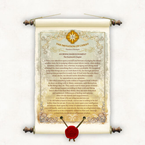
The Imitation of Christ (Latin: De imitatione Christi) - a popular book-guide to the Christian life written before 1427. The authorship of the work is attributed to Thomas à Kempis, although this is not definitively established. The book is a practical guide dedicated to Christians who, desiring salvation, walk in the footsteps of Christ. The Imitation of Christ is also the most popular ascetical work in the history of literature with a universal appeal beyond the Christian religion. The work consists of independent books and chapters containing instructions and wisdom on various aspects of the human quest for a worthy life. We offer you an original series of publications containing selected excerpts from this famous book. The form and charter of the work allow for random reading of individual chapters without direct reference to other parts of the work. Thus, we offer selected separate excerpts from the book, according to your tastes and needs. The themes and scrolls presented on our site are only an illustrative visualization of the series. To your order we will make any fragment of the book, provided that its size does not exceed a standardized page, that is, about 1800 characters with spaces and special characters. In selecting the text fragment you are interested in, we suggest using the study on the page : https://www.leaderu.com/cyber/books/imitation/imitation.html
-
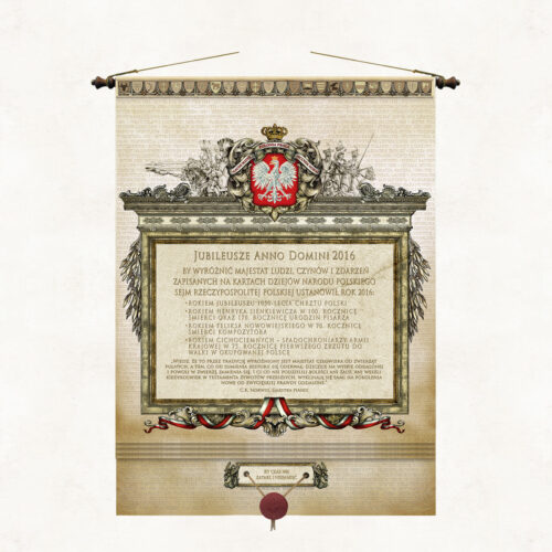
The board dedicated to the anniversaries enacted by the Sejm for 2016 is an original form of supporting the Sejm's initiative and cementing it in the public memory for years to come. The Polish Sejm has been enacting patrons of consecutive years since 2011, making this tradition relatively new. The introduction of this practice was intended to honor important historical figures, events, anniversaries and themes that play an important role in Polish culture, history and heritage. Each year, the Sejm selects several patrons whose activities or achievements are specifically recalled and celebrated in various initiatives and cultural and educational events throughout Poland.
-
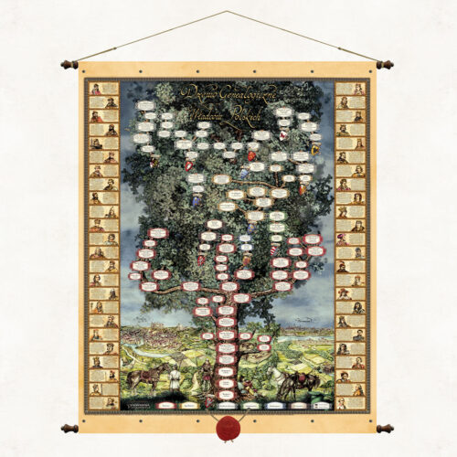
A Genealogical Tree of Polish Rulers This is a board of exceptional educational and decorative values. It beautifully and vividly shows the pedigrees of the Piasts, Jagiellons, elected kings, their coats of arms, marriages, dates of reign. Colorful engravings on the board refer to the founding myth of the Polish state from the legend of Lech, Czech and Rus, symbolically depict Polish landscapes and historical cities: Gniezno, Cracow, Warsaw. Additional instructive enrichment of the publication are portraits of rulers based on drawings by Jan Matejko. We have included them in side cartouches and provided short biographical notes.
-
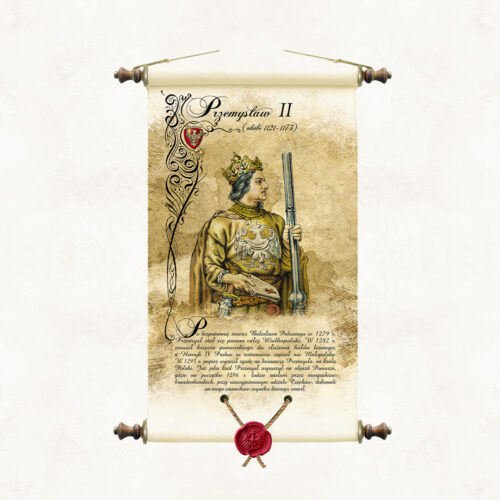
Scroll with an image of Prince Przemysl II, painted in watercolour by the artist of our publishing house, Marek Miha. The portrait refers stylistically to the series of drawings Poczet królów i książąt polskich by Jan Matejko, in which the artist did not include an image of Prince Przemysl II. PRZEMYSŁ II After the heirless death of Boleslaw the Pious in 1279, Przemysl became lord of the whole of Greater Poland. In 1282, he forced the Duke of Pomerania to pay a fief tribute. Henry IV Probus bequeathed Malopolska to him in his will. In 1295, the Pope consented to the coronation of Przemysl, as king of Poland. In 1296, Przemysl set out on a tour of Pomerania, where he was assassinated, with the unexplained involvement of Czechs, by the Brandenburg margraves.
-
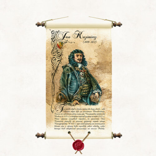
Scroll with an image of King Jan Kazimierz, painted in watercolour by the artist of our publishing house, Marek Miha. The portrait is a colourful interpretation of drawings from the series Poczet królów i książąt polskich (A Selection of Polish Kings and Princes) made in pencil by Jan Matejko. JAN KAZIMIERZ (1609 - 1672) He assumed the Polish throne at a very difficult moment for the country - the whole of Ukraine was covered by the Khmelnytsky uprising. One war had not yet ended when the Republic was attacked by Moscow (1654), followed by the Swedish deluge (1655). Despite repulsing all invasions, the first symptoms of the disintegration of the Commonwealth's political system appeared during the reign of Jan Kazimierz (the first Sejm in 1652, broken off by the liberum veto, and the nobility's rebellion). The King abdicated, leaving Poland forever.
-
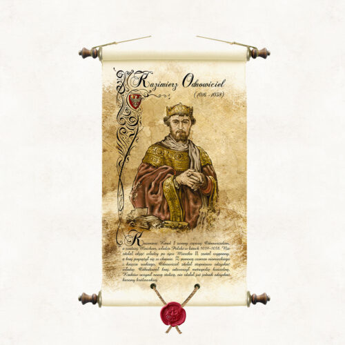
Scroll with an image of Prince Casimir the Restorer, painted in watercolour by the artist of our publishing house, Marek Miha. The portrait is a colourful interpretation of drawings from the series Poczet królów i książąt polskich (A Selection of Polish Kings and Princes) made in pencil by Jan Matejko. KAZIMIERZ THE RENEWER (1016 - 1058) Casimir Charles I, more commonly known as the Restorer, ruled Poland from 1039 to 1058. He failed to take power after his father Mieszko II, was exiled, and the country descended into chaos. In 1039, the Restorer returned to the country and, with the help of the German Emperor and a Ruthenian prince, gradually regained power, rebuilt the country, recreated the ecclesiastical metropolis and made Krakow the new capital. However, he was no longer able to regain the royal crown.
-
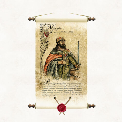
MIESZKO I (922-992) The first historical ruler of the Polish lands, the actual creator of the Polish statehood. A skilful politician and a talented leader. He fought battles for Western Pomerania and wars with Bohemia, conquering Silesia and Lesser Poland. By being baptised in 966, he strengthened the state, putting it on a par with the Christian countries of Europe. He established a Polish bishopric in Gniezno, and initiated the construction of numerous fortified towns and churches.
-
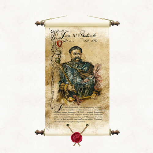
Scroll with an image of King Jan III Sobieski, painted in watercolour by the artist of our publishing house Marek Miha. The portrait is a colourful interpretation of drawings from the cycle Poczet królów i książąt polskich executed in pencil by Jan Matejko. JAN SOBIESKI (1629 - 1696) He came from a magnate family. In 1674, the nobility elected him king. Jan III Sobieski was an outstanding commander who achieved some of the greatest military successes of Polish arms, including the Battle of Chocim (1673) and the famous relief of Vienna (1683). He was also a great patron of culture and the arts. On the other hand, he did little in matters of foreign, domestic policy and economy. He did not stop the negative processes decaying the Polish state with increasing speed.
-
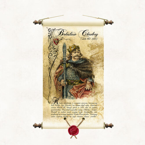
Scroll with an image of King Bolesław Chrobry, painted in watercolour by the artist of our publishing house, Marek Miha. The portrait is a colourful interpretation of drawings from the cycle Poczet królów i książąt polskich executed in pencil by Jan Matejko. BOLESŁAW CHROBRY (967 - 1025) The son of Mieszko I, the first crowned king of Poland. He was an ally of Emperor Otto III, whom he hosted in Gniezno in 1000. He waged victorious wars over Milsko and Lusatia. He organised missionary expeditions to Kyiv. He installed his son-in-law, Svyatopolk, on the throne of Kyiv, and recaptured the Chernivian lands previously occupied by Prince Vladimir of Kyiv, incorporating them into his own state. Historians are increasingly adding the word ‘Great’ to his name.
More information? Call: +48 501 69 59 69