-
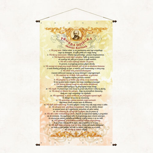
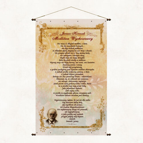
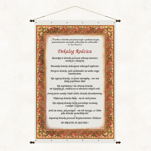
The board shows a selection of reflections from the writings of the outstanding teacher Janusz Korczak. The author expresses the child's needs, desires and dilemmas in an original form addressed to parents and educators. The engaging text makes us reflect on our attitude towards children and makes us sensitive to their needs.
-
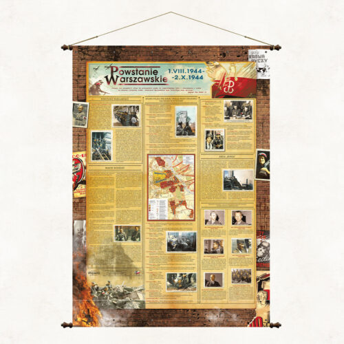
An educational board published to commemorate the Warsaw Uprising.
-
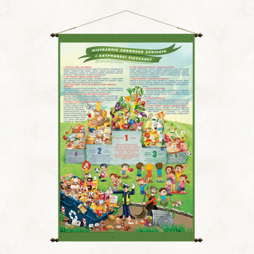
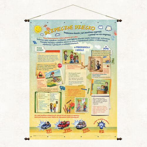
The nutrition board "Champions of healthy eating and physical activity" is a verbal and graphic illustration of the principles of healthy eating. This is an innovative scheme that groups food products and presents them in the form of a sports podium with a very clear evaluative division. Unlike the popular food pyramid scheme, which is not very suggestive for young people, our original board presents the healthiest products in a fun and clear way in the first and subsequent places on the podium. Unhealthy or even harmful dishes were pointedly placed in the garbage. The graphic message is complemented by ten essential principles of healthy eating placed at the top of the publication.
-
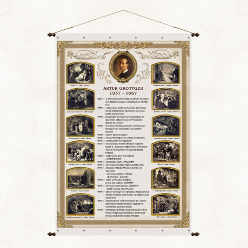
Plansz edukacyjna przedstawiająca kalendarium życia Artura Grottgera wraz z wybranymi grafikami arsysty.
-
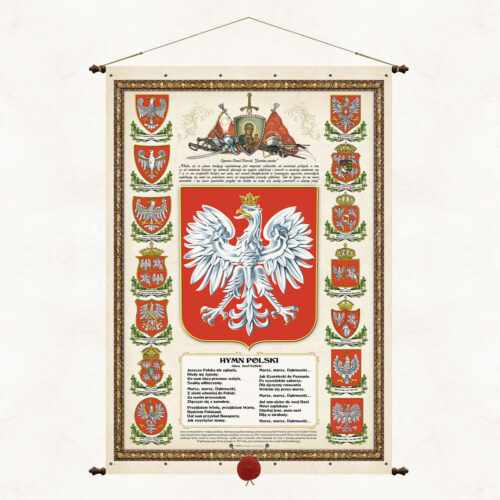
Patriotic and educational board, compendium of national symbols. We make it in various sizes so that customers can adjust it to their needs and local conditions. The publication presents the modern state emblem, a selection of historical emblems, and the full text of the national anthem (Dąbrowski Mazurka).
-
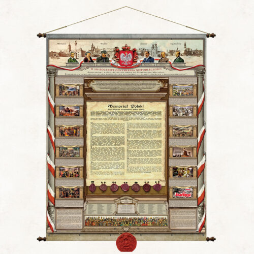
The Polish Memorial is a unique board, a one-of-a-kind vademecum of Polish history, presenting in a condensed verbal and graphic form the principles of the thousand-year-old heritage of the Polish nation. The main theme of the publication is an anniversary calendar of Polish history written in the form of a historical essay by prof. Andrzej Nowak, an outstanding scientist and committed patriot. The 100th anniversary of regaining independence became an impulse for the historian to present other significant anniversaries. Describing over 1,000 years of Polish history, the professor brings us closer to the historical continuity of Polish fate and the importance of the generational transmission of culture and tradition. At the bottom of the memorial, we have placed replicas of historical seals of Polish rulers and people and institutions significantly inscribed in Polish cultural heritage. Apart from the title essay, there are symbols of national identity on the board: - national emblem and anthem, - engravings depicting the former capitals of Poland - Gniezno, Krakow and the modern capital - Warsaw, and Częstochowa as the spiritual capital of the country, - images of the most outstanding Poles, those considered to be the Fathers of Independence in 1918, and representatives of generations that have maintained their independence deed and legacy over the millennium, - significant messages and statements about Poland and Poles, - a brief description of the history of Poland's independence and symbolically illustrating it with engravings. The canons of Polishness written down and illustrated on the board by the editors, apart from their educational function, are also an aesthetic element of the patriotic decor of apartments and offices, expressing respect and attachment to tradition.
-
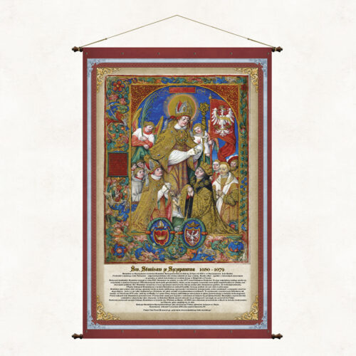
The board commemorates Saint. Stanisław of Szczepanów (also Stanisław Szczepanowski), bishop of Krakow, martyr, saint of the Catholic Church and one of the main patrons of Poland. The illumination placed on the board shows Saint. Stanisław as the patron saint of the Kingdom of Poland and comes from the work of Jan Długosz entitled Catalog of the Archbishops of Gniezno (Latin: Catalogus archiepiscoporum gnesnensium) from before 1476. The author of the painting is the Cistercian Stanisław Samoshootnik, a. Stanisław of Mogila (1480 - 541) - Polish painter, illuminator and miniaturist. The illustrations for the catalog were made several dozen years after Jan Długosz's death.
-
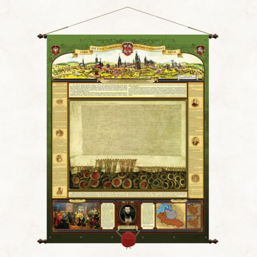
The board was published in 2019, on the 450th anniversary of the Union of Lublin. The attractive, stylized form of the publication presents the history and significance of that great event. We presented: – content of the act of the Senate of the Republic of Poland establishing 2019 as the year of the Union of Lublin – a photocopy of the Act of the Union of Lublin in actual size – panorama of Lublin from 1614 – extensive fragments of the original text of the union – a brief historical outline of events related to the Union of Lublin – fragment of the will of King Sigismund II Augustus referring to the Union of Lublin – image of Jan Matejko's painting - Union of Lublin – Map of the Polish-Lithuanian Commonwealth from the 17th century. The board is topped with a wax seal with an eagle, is 98 cm wide and is mounted on decorative bars.
-
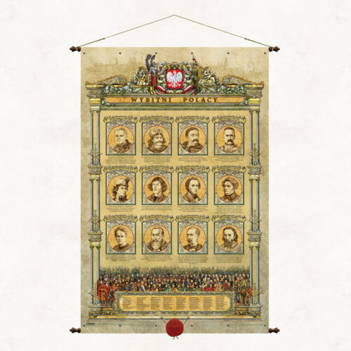
The board presents a selection of over 120 outstanding Poles who made a significant contribution to the creation and strengthening of Polish statehood, culture and national heritage. Their images appear at the bottom of the map and are numbered, which allows easy identification of the person according to the list below. In the center of the board there are portraits of 12 figures particularly important to Poles and our national tradition.
-
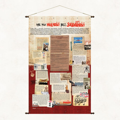
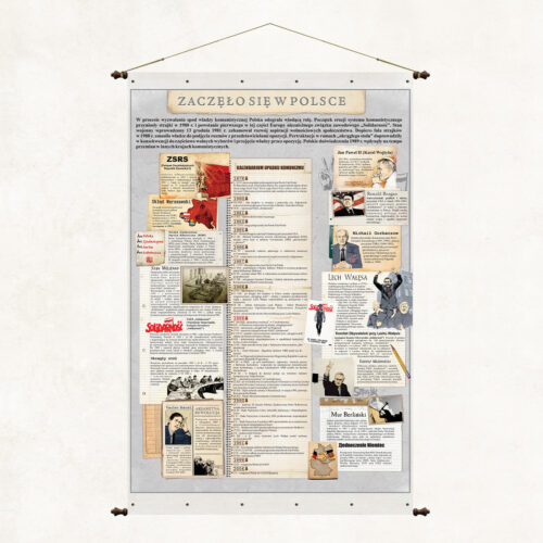
Wartościowa edukująca historycznie publikacja, której intrygujący tytuł pobudza do zastanowienia, o jakie wydarzenie historyczne chodzi. W Polsce miało początek wiele wydarzeń, ale nie wiele z nich jest tak fałszywie interpretowanych przez część europejskich historyków, jak właśnie początek i przyczyna upadku reżimów komunistycznych a szczególnie tego najgorszego – Związku Radzieckiego. Staramy się poprzez tę planszę dać udokumentowaną odpowiedź na istotne pytania dotyczące tamtego okres i tamtych wydarzeń.
-
"Poland is a land of ancient primeval forests and thousands of lakes spread on hills and plains between the Baltic Sea and the high Tatra Mountains. History has endowed our country with a unique place on Earth, thanks to which beautiful Polish landscapes four times a year undergo extraordinary metamorphoses delighting with the dynamics of nature, its unusual colors and moods." The map “Nature of Poland” is a publcation unique and beautiful, full of images and symbols of the natural heritage of our country. It is a map - sanctuaries of Polish nature, which should, like the works of Mickiewicz, go under thatched roofs to give and strengthen in us a sense of connection with nature and responsibility for it. Maintained in the convention of old cartographic works, it tells about the treasures of nature that have survived to our time. It presents in decorative cartouches business cards of Polish national parks, gives the most important natural and geographical information about Poland, describes the forms of environmental protection used in our country, beautifully promotes Polish nature. Wishing to popularize the natural beauty of our country, we have published two twin maps, “Nature of Poland” and “Forests of Poland”, which in a complementary way present the overall resource of Polish nature. National parks are the mothers of Polish flora and fauna, but they are not a separate and independent natural creation, they are part of our natural environment, which includes many components such as forests, landscape parks, areas of protected landscape, agricultural land and, of course, water. National parks account for only 1% of our country's land area. The remaining 29% is made up of forest areas owned by the State Forestry Service.
-
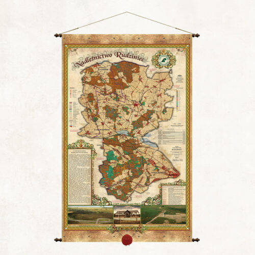
A map of the Rudziniec Forest District, one of 38 forest districts that form part of the Regional Directorate of State Forests in Katowice. The map presents a brief description of the forest district, forest divisions and forest habitat types.
-
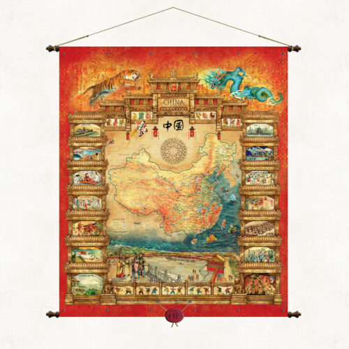
A unique map filled with oriental style illustrates both the cartographic image of China and the specific nature and culture of the center country and its cantons. At the bottom of the map is one of the most recognizable symbols of China, the Square of Heavenly Peace (Tiananmen Square). The side frames show the most famous monuments and symbols of Chinese culture and tradition. The publication is bound on wooden poles with decorative tips and topped with a suspended Chinese wax seal. The publication belongs to a series of maps created at the request of the Polish Olympic Committee. It was made in 2008 for the XXIX Summer Olympic Games, which took place in Beijing, the capital of China.
-
This is a unique map on our publishing market. In addition to its classic cartographic content, it also presents a unique landscape image of Poland. We have combined two complementary views on one map. Our artists have painted Poland “from an eagle’s eye view” to illustrate the beauty of our homeland and its assets. Wanting to show the Polish mountains in a clear perspective, we have reversed the observer’s position to the north. We have marked the panorama with the most important cities, monuments, rivers, and forests. This is how this unique and practical landscape publication was created.
-
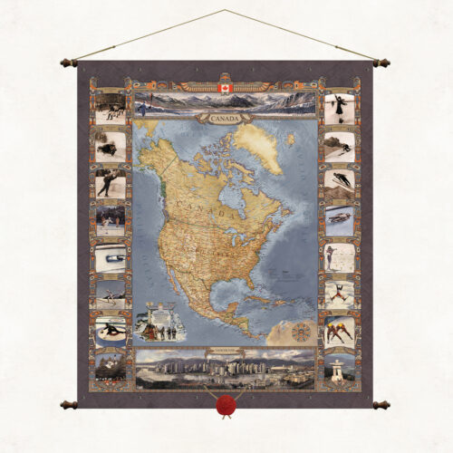
A map of Canada, or rather a map of North America. A publication commissioned by the Polish Olympic Committee for the XXI Winter Olympic Games, which took place in the Canadian city of Vancouver on 12–28 February 2010. This is another in a series of Olympic maps. The map frames and cartouches refer stylistically to the totemic culture of the North American Indians. The upper part of the publication shows a winter view of the Rocky Mountains region, where the games were held, the lower part shows the panorama of the city of Vancouver.
-
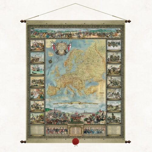
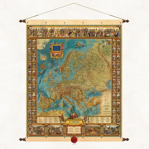
The Map of Europe is one of the leading publications of our publishing house, created by outstanding Silesian artists Kazimierz and Ksawery Kaliski. The publication’s original graphic and thematic composition captivates with its colors and richness of content. The unique map refers stylistically to old editorial forms, but presents Europe much deeper, fuller and more beautifully. In symbols and images, it shows the cross-sectional richness of the centuries-old cultural heritage of the old continent, its state and national specificity. It is framed on wooden rods with decorative ends and topped with a suspended wax seal.
-
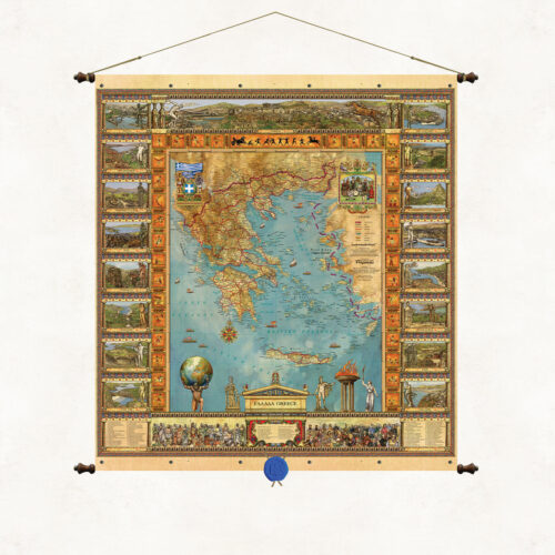
The beautiful graphic and color composition of the map illustrates both the cartographic image of the lands of Greece and its historical and cultural heritage. The enchanting landscapes, ancient architecture and a list of outstanding figures from the history of Greece shown in cross-section on the map are a compendium of knowledge about the cradle of our civilization. The publication belongs to a series of maps created at the request of the Polish Olympic Committee. It was made for the XXVIII Summer Olympic Games held in Athens (Greece) in 2004.
-
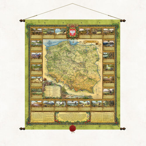
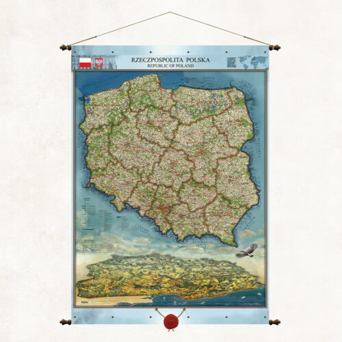
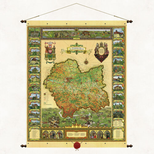
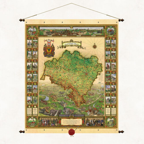
The stylized graphic and color composition of the map illustrates both the cartographic image of contemporary Polish lands and the natural and cultural specificity of individual regions. The side cartouches refer to the contemporary administrative division of the country. Each voivodeship is illustrated in a separate frame. There we can see its characteristic monuments, terrain, vegetation, and regional folk costume. At the bottom of the map we have shown a list of outstanding figures from the history of Poland. Illustrations depicting great leaders, scientists and artists are an instructive story about the thousand-year history of our country.
-
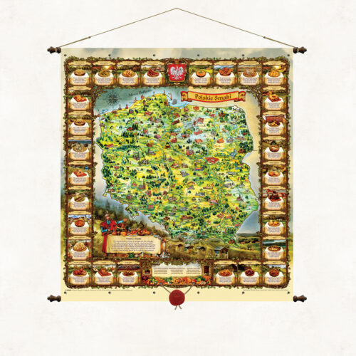
Here is a country abundant in goods from the Baltic Sea to the peaks of the Tatra Mountains Here food recipes are part of an old culture with a hint of Slavic spirit and for the senses as well as the belly. It is an old Polish tradition to feast among delicacies so let's sit in a circle together the table is already set. And let's choose Polish dishes because it's a delight to eat. The unique map Polish Flavors brings the uniqueness of Polish culinary tradition closer. The rhymed descriptions of the most famous Polish dishes surround a colorful, landscape representation of the Polish lands. A lavishly set table, a nobleman in a kontusz and an old-Polish inviting gesture encourage the tasting of Polish dishes. The original descriptions of the dishes are poems by Father Marek Wójcicki written especially for this publication. The publication is thematically inscribed in our publishing mission, which is to promote Poland, its beauty, history and traditions. Images painted by artist Marek Michna and illustrator Radoslaw Jaszczuk.
-
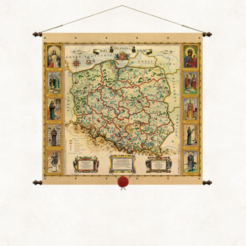
This is the first publication of the Pergamena Publishing House, created as a souvenir of the millennium year. Maintained in the convention of old maps, it presents the diocesan administrative division of the Catholic Church in Poland. The side cartouches feature images of the Merciful Christ, Our Lady of Częstochowa and outstanding saints from the history of the Polish church. The lower cartouches feature the blessing of St. John Paul II and the text of the Chaplet of Divine Mercy.
-
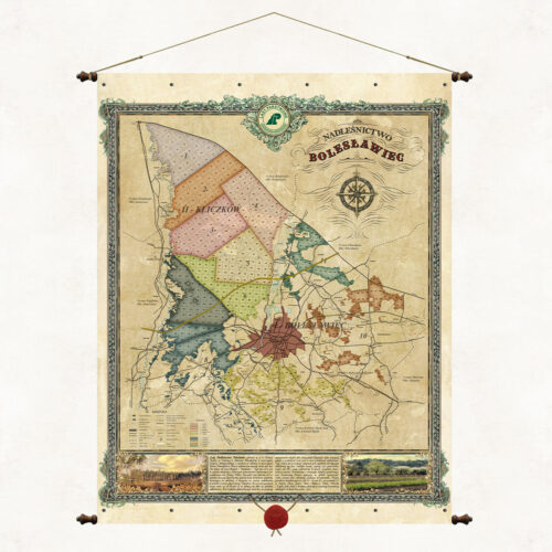
An overview map of the Bolesławiec Forest District, one of 33 forest districts that are part of the Regional Directorate of State Forests in Wrocław. The map presents a brief description of the forest district, forest divisions and forest habitat types. The Bolesławiec Forest District is located entirely within the Lower Silesian Voivodeship in Bolesławiec County. It consists of 6 communes: Bolesławiec, Warta Bolesławiecka, Osiecznica, Nowogrodziec, Gromadka and the City of Bolesławiec.
-
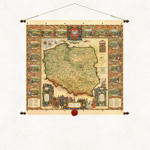
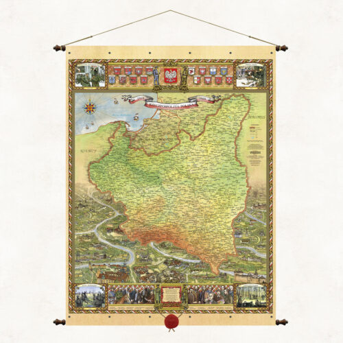
The map shows the borders of the Republic of Poland in the interwar period, along with the administrative division of the country. In addition to the cartographic layer, the map will include engravings presenting the panorama of the lands of the Second Polish Republic with characteristic monuments, coats of arms of the then voivodeships, a list of outstanding figures, creators and leaders of the Second Polish Republic, images of the four independence uprisings that determined the shape of the borders of Poland at that time (Battle of Warsaw, Greater Poland Uprising, Sejny Uprising and Defense of Lviv).
More information? Call: +48 501 69 59 69